The Woking Green Belt Review
Public Consultation on the Site Allocations Development Plan Document
(SADPD)
5th November to 17th December 2018
BACKGROUND
A new Site Allocations DPD has been published for public consultation. The document shows where Woking Borough Council (WBC) plans to build houses in the next nine years, and which land it will want to remove from the green belt for building in the period 2027 – 2040. This is the last chance for members of the public to have their say before WBC submits the Document to the Planning Inspectorate for examination. The Document and supporting papers are available on the WBC website at www.woking2027.info/allocations
SUMMARY AND LOCAL MAP
The main change from the previous proposal is that WBC has removed the Martyrs Lane site from consideration despite its suitability for development, in part because the principal land owners, McLaren and New Zealand Golf Club, have indicated that they would not voluntarily sell their land for development. It was considered unlikely that compulsory purchase orders would be upheld by the courts. The proposal is to revert to the recommendations of the 2015 SADPD with only minor amendments for the period up to 2027. Major amendments have been incorporated for the period 2027-40.
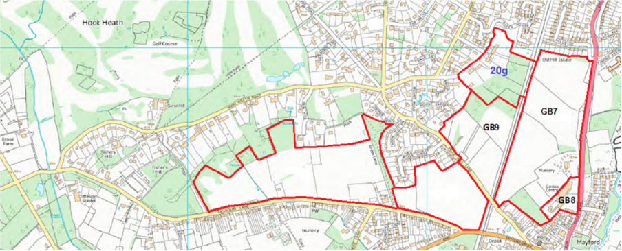
The Council has confused things by changing the designations of the selected sites from those used in the earlier stages of the process dating back to 2015. The map below shows the new designations of the Green Belt sites in the immediate vicinity of Hook Heath.
PROPOSAL
A pre-2027 amendment of significance to us in Hook Heath is that the northern portion of the Egley Road site, now called GB7, should no longer be safeguarded for housing, but instead be safeguarded for use as an urban open space. [Note that the Hoe Valley School, a leisure centre and an athletics track have already been built on the central portion of GB7, even though it is still within the Green Belt.] The reason is to preserve the gap between Woking and Mayford Village in accordance with local wishes. It is apparently believed that the open nature of the northern part of GB7 would be better protected from predatory building developers when designated as an urban open space than it would be if it was retained as an otherwise unprotected and isolated piece of Green Belt land. This change could have significant implications for Hook Heath.
For the period 2027-40 the new proposal contains a number of changes affecting Green Belt sites previously safeguarded for housing. Those of most concern to Hook Heath and Mayford relate to the sites north of Saunders Lane. They will no longer be safeguarded for development, but will remain within the Green Belt. Cllr Bowes, the planning portfolio holder, has described these two sites on rising ground of landscape significance, along with a third historic site in Pyrford, as being among the most valuable pieces of Green Belt land in Woking which have should been the last to be considered for development, not the first.
Reductions in the amount of Green Belt land to be safeguarded have been made possible by building more densely in the town centre, where several tower blocks are currently under construction and more are at the planning stage. It is notable that a number of councillors have objected that since the dense developments in the town centre were not foreshadowed in the 2015 proposals they should be regarded as windfall sites, and therefore not counted towards meeting the housing requirement. They seem to have forgotten that the 2015 paper never got beyond the consultation stage. The Planning Inspectorate will be asked to approve the 2018 SADPD, and in 2018 the tower blocks under construction in the town centre are there for all to see.
THE ISSUES
There does not appear to be any change to the proposed status of the only Green Belt designated site within the HHRA area (north of Hook Hill Lane), now designated GB9, that was safeguarded for green infrastructure post 2027 in the 2015 SADPD. The justification for removing GB9 from the Green Belt given at the time was that it would otherwise have become an isolated pocket of Green Belt land. Now that the Saunders Lane sites will remain in the Green Belt this argument is no longer valid. It is certainly our preference to retain GB9 in the Green Belt. In the new SADPD the site is to become urban land, although still safeguarded for green infrastructure. WBC has not indicated what it wishes to do with this land and thus there cannot be a strategic reason for removing it from the Green Belt.
It can be argued that since the role of a public recreation space is to be assumed by the northern part of GB7, there is no longer a need for another one, especially as the only new housing in the area will be on the southern part of GB7 behind the existing Garden Centre and no housing is planned for the Saunders Lane sites. Even if GB9 is still required for green infrastructure, that is a legitimate use of Green Belt land. There is no need to remove GB9 from the Green Belt.
Even worse news is that tucked away on page 275 of the SADPD in an annex that repeats the outdated 2015 SADPD reasoning for removing GB9 from the Green Belt there is a throwaway statement that the Green Belt site to the north of GB9 will become urban land on adoption of the SADPD without any explanation or reasoning. The site was designated 20g in the (discredited) Peter Brett Report and has not been mentioned since. It is unacceptable to remove land from the Green Belt without good reason. It would appear that by constraining the debate on the Martyrs Lane option to a comparison with only those Green Belt sites safeguarded for house building post 2027, WBC believes it can avoid further debate on, and making changes to, all other proposals made in the 2015 SADPD.
We see no good reason for removing 20g from the Green Belt and none have been published. If GB9 and 20g remain within the Green Belt they, together with land north of Saunders Lane, will form a continuous green corridor of protected land for wild life stretching along the Hook Heath escarpment as far north as Allen House Park. 20g will link with the northern part of GB7 and reinforce any argument that the Mayford Village Society may make for retaining that land in the Green Belt as an alternative to it becoming urban open space.
ACTION NEEDED
The HHRA will be making a submission to WBC in due course after taking professional advice, but we must also demonstrate public support for our case. You will have gathered that protecting the open land north of Hook Hill Lane is now our major priority. The arguments for keeping the land within the Green Belt are sound, and deserve your support. If you agree, please find time to look at the Site Allocations Development Plan Document on the WBC website. It is too long to read in its entirety unless you are really keen, but do take a few moments to peruse the section on GB9 (pages 273-276) and submit a comment in your own words saying why you believe GB9 and 20g should be retained in the Green Belt.
Points to make to support the case for retaining the land north of Hook Hill Lane in the Green Belt are:
- GB9 and 20g will not be isolated pockets of Green Belt, but link to the rest of the escarpment north of Saunders lane to form a continuous corridor along the Hook Heath escarpment.
- The function previously assigned to GB9 (green infrastructure) is now to be fulfilled by the northern part of GB7.
- Only a small amount of additional housing at the southern end of GB7 is proposed for the area.
- Even if GB9 is still required for green infrastructure then that is a legitimate use of Green Belt land
You may also want to look at the section on GB7 (pages 263-268) and suggest that as much as possible of the site should be retained in the Green Belt and remove only the land needed for housing at the southern end of the site.
Points to make in supporting
- A school, a leisure centre and an athletics facility have been built on the central part of GB7 without the need to remove it from the Green Belt.
- The open space role can be equally well be met by the northern part of GB7 without removing it from the Green Belt.
It may also be helpful to commend the Council on its decision avoid building on the land north of Saunders Lane.
Please submit your comments by 5pm on 17 December 2018 to WBC by: completing the online representation form at www.woking2027.info , or by completing a representation form and sending it by e-mail to planning.policy@woking.gov.uk , or by e-mailing your comments to planning.policy@woking.gov.uk , or by post to the Planning Policy Team, Woking Borough Council, Civic Offices, Gloucester Square, Woking, Surrey, GU21 6YL.